THE DOST-PHIVOLCS, through the Deterministic Liquefaction and Tsunami Hazard Mapping of Selected Low-lying Areas in the Philippines using GIS, AI, and Geophysical Techniques (DeLTA) Project under the Accelerated Earthquake Multi-hazards and Risk Assessment Program in the Philippines (ACER), conducted its second leg of coastal field investigation in Iloilo to enhance the tsunami hazard map of the province.
This is in partnership with Iloilo Provincial Disaster Risk Reduction and Management Office (PDRRMO), Iloilo City DRRMO, and municipal DRRMOs.
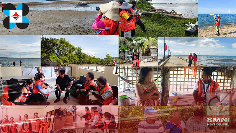
From January 19-26 2025, the DeLTA Project team together with the staff from the Local DRRMOs of Barotac Nuevo, Dumangas, Banate, Anilao, Barotac Viejo, Ajuy, Concepcion, San Dionisio, Batad, Estancia, Carles, and Iloilo City, visited the highly urbanized and tsunami prone areas on the northeastern coasts of the province and deployed remotely piloted aircrafts (RPAs) to capture the present elevation of the area, collected sediment samples, and performed beach profiling.
The team also conducted interviews with local residents to obtain insights on the relative sea level changes, sea level disturbances, and other extreme wave events that may have occurred in their area, such as the 1948 Magnitude 8.2 Lady Caycay earthquake and tsunami. These field activities are crucial to validate the area’s topography and refine the tsunami hazard map of Iloilo Province.
The DeLTA Project aims to apply the developed methodologies in accelerating the generation of provincial- and city-scale tsunami hazard maps of the Philippines.
Editor’s Note: This article has been sourced from the Philippine Institute of Volcanology and Seismology (PHIVOLCS-DOST) Facebook Page.